Land Area and Classification
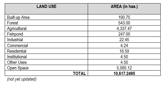
The total land area of San Lorenzo is 10,617.2495 hectares distributed among 12 barangays (Table 1). This is about 17% of the total land area of the island province of Guimaras. It is composed of twelve (12) barangays where six (6) are coastal and the other are upland barangays. Table 2 shows the land use classification of San Lorenzo with the corresponding land areas. Some values are approximate and need to be validated as they do not add up to the total land area of the municipality.
Table 3. Land area classification of San Lorenzo, Guimaras.
CLIMATE
There are two distinct climates in the municipality, the wet and the dry season, ideal for planting of multiple crops with rice as the main agricultural product during rainy season and salt production as the main livelihood activity of the coastal populace during summer or dry season that starts from December and ends at April.
Rainy season starts at May to November which favors for good rice production and San Lorenzo is considered as the rice granary of Guimaras. Heavy rains fall middle of July to September which enable good preparation of non-irrigated rice fields.
By geographic location it is seldom visited by typhoon. If ever typhoon reaches the area, which usually occurs once in every five years, it is very rarely of catastrophic intensity. The natural hydrological system of the town makes it a flood-free locality. However, a parcel of lowland in barangay Sebario and M. Chavez experience flooding during prolonged rainy days. San Lorenzo is not within the country’s typhoon belt although tropical storms and locational typhoons pass through this Municipality. It has one identified fault line located at Sitio Madrid, Brgy. M. Chavez to Brgy. Cabano.
San Lorenzo has a mild and cool climate brought about by sea breeze. It has two pronounced seasons: Dry and Wet. The dry season is caused by dry northwest wind from November to April. The Wet Season is brought by the southwest monsoon, whose humid air brings rain during the rest of the year.
RAINFALL
LIMITATIONS OF EXISTING CLIMATA DATA
Climate variations have been observed in Guimaras as manifested by conditions wherein it is raining in one area but just in another area it is dry. Micro-climatic condition differ in areas of the island and require more detailed climatic measurements and advanced weather observation facilities. This is very significant considering agriculture; fisheries and tourism are the primary economic drivers of the Municipality of San Lorenzo and province of Guimaras as a whole.
The southwest monsoon (hanging habagat), which ushers in the wet season, starts in June and ends in September. It is characterized by moisture-laden maritime tropical (MT) winds prevailing from a southwesterly direction due to high pressure system over the Australian Continent, from which diverging winds move towards a low pressure system over South and Southeast Asia including Mainland China.
TEMPERATURE
PAG-ASA does not have a separate data for the province of Guimaras, and the figures for Iloilo, the nearest data source, is used. Mean temperature readings are higher for approximately the same period. The baseline temperature average is more than 30 degrees Celsius, more than 3 degrees higher than the NMRDC figures. The minimum baseline temperature according to PAG-ASA is 30.2 degrees Celsius in the quarter covering the months of December-February. This is higher than the 25.1 degree Celsius minimum baseline in temperature in December as indicated in the NMRDC data.
TOPOGRAPHY
The topography of the Municipality varies from slightly rolling hills to and almost flat or gradually inclined plains sliced by Cabano river at its centermost which flows from the Municipality of Sibunag passing Brgy. Sapal and Aguilar which finally flows to the eastern coast at the boundary of Brgys. Cabano and M. Chavez.
The terrain of the municipality comprised of low-lying alluvial plains in the eastern, central and south-eastern parts of the rolling uplands in the northern, western and south-western sides. Barangay Cabano covers a wide-area of 498.02 hectares within the slopes of 0-3% range figured to 1,756.68 hectares of the twelve (12) barangays, eight (8) have partly slope areas of 3-8% range or gently sloping or undulating. This excludes barangays: Aguilar, Constancia, M. Chavez and Tamborong. There is around 1,780.40 hectares of the eight (8) barangays with slopes belonging to the range of gently undulating or sloping. There are no steep hills and mountain in San Lorenzo.
Figure 4 . Municipality of San Lorenzo Topographic Map

SOIL TYPE AND EROSION
Based on morphological standards, San Lorenzo has the soil type suited to multiple crop production. Existing soil types are cystricnitrosol, orthicbiresol, thicnicluvesol and beach sand.
No apparent erosion covers an area of 2,762.50 hectares; moderate erosion covers an area of 7,343 hectares and 292.50 hectares are severely eroded areas. 57 hectares have unclassified erosion. Moderate erosion is apparent to the entire land arms while severe erosion is confined to portions of Brgy. Sapal and Tamborong.
SLOPE RANGES
Describes the different elevation, slope range and percentages of the slopes. Elevation is the height of the place from the sea level, while the slope range describes the topography of the land. Gently sloping means the area is somewhat flat with slight slopes usually along the banks of waterways and natural drainage. Undulating to rolling are those area that has a small portion of flat lands and low hilly portions. These are the areas that are still suitable for agriculture or arable. Rolling to hilly locations can be tapped for agricultural production but are suggested to be used as pastureland and orchard areas. Percent (%) of slope means the number of degrees the area is from a horizontal angle.
Table: 4 Slope Ranges
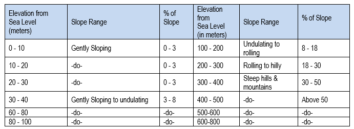
Figure 5. Slope Map of the Municipality of San Lorenzo

HYDROLOGY
San Lorenzo has available water sources that can potentially irrigate farm crops and provide water for household use. However, water scarcity, especially during the dry season, remains to be a large problem in San Lorenzo. The main watershed boundaries are river basins and creeks.
There are seventeen creeks and three rivers spread out all over the municipality. Cabano River is the largest river and the major source of the irrigation system of Barangay Cabano while Sebario and Igcawayan Rivers are also supporting irrigation needs in these two barangays. Potable water source at Sitio Nagay, Barangay Sebario can support the water needs of Sitio Proper of this Barangay. Characteristically all rivers are of intermittent type, silted, and shallow channeled. The existing condition of Cabano River is dramatically critical for irrigation support.
Rivers and Creeks
San Lorenzo has only one main river, the Cabano River which has an estimated length of more than seven (7) kilometers that flows from Tamborong , Aguilar to Barangays Gaban, Cabano and M.Chavez. Several creeks serve as natural drainage to include Suclaran creek, Igcawayan creek, and Sebario creek which all drain toward the eastern side of the Municipality
Figure 6. Cabano River (indicated by the red arrow) is the main river of San Lorenzo.
Springs
There are seven (7) identified springs spread across the municipality which are the sources of water for domestic and agricultural use. A source of potable water is found in Sitio Nagay, Barangay Sebario which can support the potable water needs of households in the Barangay.
Falls and Lakes
No falls had been found in the municipality, unlike other municipalities of the province. No lakes are found either.
Forest and Forestlands
The total forest area of San Lorenzo is about 543 hectares which include about 400 hectares of timberland and private forest plantation (Municipal Profile of San Lorenzo). This represents only about 5.11% of the municipality’s total land area of 10,617.12 hectares. About 48% of San Lorenzo’s land area is designated as open spaces.
The most recent assessment on the forest and watershed resources of San Lorenzo was conducted around the Tumalintinan Fish Sanctuary under the PRA-RSA of Guimaras Strait of the PRDP NRM component. The watershed area of San Lorenzo straddles both the Cabano Watershed, which covers part of the municipalities of Jordan and Sibunag, and the Mantanigi Watershed which also covers large portions of the Municipality of Buenavista. Forest land (i.e with perennial crop/trees) within the watershed is estimated to cover 8,499 ha while shrubs and wooded grasslands cover 1,318 ha. The watershed has an area of 5,164 ha for agricultural production (i.e. annual crop), which may contribute to effluent runoff that can adversely impact the MPA. The aggregate watershed area covering the three barangays (Cabano, M. Chavez and Suclaran) adjacent to the Tumalintinan Fish Sanctuary is 3,218 ha.
Mangroves
With regards to mangroves, there are twelve (12) locations surveyed, Four (4) in barangay San Enrique, one (1) in barangay Suclaran, two (2) in barangay Cabano, four (4) in barangay Igcawayan and one (1) in barangay Sebario.
The total length of mangroves growing along the foreshore of San Lorenzo is 5,212 meters. Suclaran has the most with 1,860 meters. The substrate is muddy to sandy soil and some rocky portion. The mangrove stands is mostly dominated by Avicennia spp, and with some patches of Sonneratia and Rhizophora spp. Along with the open foreshore areas are patches of mangrove associates, indigenous beach species of trees, palms and shrubs.
Shoreline
The shore line of the municipality of San Lorenzo is mostly sandy to muddy substrate and with long spans of mangrove forest. There are two (2) water drain outlets from the upland, a river and a creek. One is a creek coming from the upland of Cabano with its outlet near the Cabano wharf and the other one the Igcawayan river pouring out in the mangrove areas of barangay Igcawayan. Siltation is high in areas where water is poured out from the mouth of the river and creeks coming from the denuded upland.
Beach Forest/Vegetation
Beach Forest refers to perennial vegetation growing along the beach or edges of the coast where seawater can reach or affected by tidal action, and often characterized by sandy substratum. The Municipality has limited beach forest generally vegetated by mangrove trees such as pagatpat (Sonneratia sp.) and piyapi (Avicennia sp) such as found on the Nadulao Island, Barangay Igcawayan, in Bgry. Suclaran where the Tumalintinan MPA is located. Several coconut trees can also be found on the edges of the beach. No estimate of area or extent of beach covered by this kind of vegetation. Future assessments should include these estimates.
Mineral Resources
The mineral resources present in the Municipality of San Lorenzo based on available data include limestone, iron, copper, and sand and gravel although specific available reserves for these have not been quantified.
Estuaries
The delta formed by the Cabano River can be considered as the main estuary of the Municipality. The Cabano River is the boundary of the Barangay M. Chavez and Barangay Cabano. Areas around the major creeks, namely, Suclaran creek, Igcawayan creek, and Sebario creek as they meet up with the sea also forms estuarine areas. Sparse growth of mangroves line these areas as most parts have been converted to fishponds and salt beds. No area estimates nor biophysical assessment of these estuarine ecosystems are available. Future updating of the coastal resources of San Lorenzo should include these areas.
Tidal Flats
Tidal flats are not very extensive in san Lorenzo, and are found around river deltas or near mangrove areas. The PRA-RSA found the waters around the Tumalintinan Point Fish Sanctuary was highly turbid although there was no major rivers or creeks near the area that could have contributed to the sedimentation, which was probably due to sediment resuspension due to high wind and strong wave action. The substrate on the tidal flat was generally sandy with coral rubbles and rocks that extended from the mangrove to the coral reef ecosystems, with patches of small rock boulders in deeper waters. Macro-invertebrates polychaete tube worms, gastropod mollusks, some bivalves, and brittle stars were sighted in the soft bottom areas.
Vulnerability to Disasters
San Lorenzo has its share of vulnerability to disasters, such as very high susceptibility to flooding (in Sitio Nadulao Island Brgy Suclaran), high susceptibility to landslides (Bgry. Sapal, Igcawayan, Sebario, Constancia and Tamborong). The location of the municipality along Guimaras Strait, a very busy shipping and navigational highway, makes it vulnerable to maritime disasters. Fortunately the infamous M/T Solar 1 oil spill that hit Sibunag and Nueva Valencia hard in August 2006 (Province of Guimaras and PEMSEA, 2012) missed San Lorenzo by a thin margin. San Lorenzo is one of four municipalities in Guimaras that has an active Faultline, thus, making it vulnerable to seismic events such as earthquakes. To improve its hazard and disaster preparedness, San Lorenzo must develop its Municipal Disaster Response Plan, implemented through the Disaster Coordinating Councils at barangay, municipal and provincial levels.
